|
|
|

|
Services:
|
TDEM Article
|
|
Case Study: The Evolution of Airborne Time Domain Electromagnetic Applications for Geologic Mapping; a Noranda Perspective. Michael J Schaefer, Noranda Mining and Exploration, Tucson, Arizona John Gingerich, Noranda Mining and Exploration, Toronto, Ontario Jean Lemieux, Geoterrex Ltd., Ottawa,
Ontario
Abstract The advances in airborne time domain EM over the last seven years have facilitated the evolution of this technology into an effective mapping system from what has been ostensibly considered primarily a massive sulphide targeting tool. During this period Noranda undertook a series of programs which provided insights into the technical issues and interpretation challenges the use of airborne time domain electromagnetics (TDEM) technology presents to exploration geologists and geophysicists. Following a model study and test flying program over a sediment hosted copper prospect on Victoria Island in the Canadian Arctic, a series of covered terrain porphyry copper exploration mapping programs were undertaken in southwest Arizona and Sonora Mexico between 1993 and 1997 using both the QUESTEM and GEOTEM commercial airborne TEM systems. The results of this work were encouraging but underscored the need for ground validation programs and robust geologic models to properly interpret the data. A need for lower noise and better calibrated EM systems was also recognized. The thrust of Airborne TDEM technology development has been to improve conductor (massive sulphide) detection to greater depth in ever increasing complex geologic environments. This application is often referred to as bump finding in reference to discrete anomaly amplitude signatures superimposed along ostensibly flat background, profiled channel data. However, as processing software improved (i.e. conductivity depth inversion/transformation algorithms, CDI/CDT) and integrated exploration models were applied, it became clear that this technology could be applied as a broad geologic mapping tool. This required a shift in how the data was viewed; instead of "anomaly picking" which normally utilized ~1% of the data, the previously ignored background data which contained useful geologic information became the focus of analysis. As airborne TDEM instrumentation and interpretation software improved, airborne TDEM has become a much more effective tool for geologic mapping. GEOTEMDEEP surveying in 1997 over Noranda’s San Jose (AZ) and adjoining Sol porphyry properties reliably identified known subsurface bedrock features ranging in depth of 150m to 200m. Diamond drilling results suggest that mapping locally defined the bedrock interface to depths in excess of 300m. Evidence also exists to suggest that lithologic discrimination under cover is locally possible. Survey results over the Poston Butte (AZ) porphyry copper deposit is an example of how airborne TDEM technology could be used as a direct targeting tool. The signature is unfortunately not unique, and similar to inliers of conductive cover. For this reason ground validation programs are essential components of any exploration program. While airborne TDEM technology has
evolved to the point where pseudo 3-D mapping (spatial analysis of 1-Dimensional
CDTs) capabilities are possible, more reliable and robust inversion software,
improvements in system noise levels and stability, plus a better understanding
of the geologic models are still needed to provide reliable interpretation.
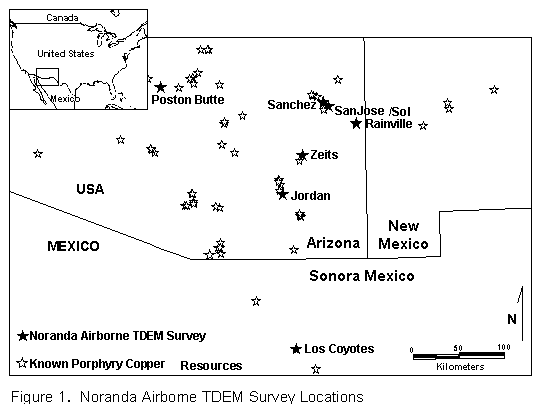
Introduction In 1991 Noranda was evaluating projects where Helicopter Electromagnetics (HEM) resistivity mapping programs provided valuable geologic information but insufficient depth of penetration, usually less than 50m. This often compromised exploration objectives which had a target range from 75m to >250m. While issues existed as to system calibration and stability, inversion software (e.g. Sengpiel) provided reasonable subsurface geologic mapping at shallow depths. By contrast fixed wing airborne TDEM surveys could often provide improved targeting capability, however this came at the expense of geologic mapping. In addition, deposit models were identified which were not necessarily classic conductors (Sedex, Porphyry). Rudimentary processing techniques such as contouring amplitudes of various channel responses and calculated time decay constants (tau) provided some indication to geologic trends but issues with respect to system base frequency, calibration, sensor-aircraft configuration and noise levels made it difficult to provide the resolution required to differentiate weakly contrasting or conductive stratigraphy. A technical review coupled with model studies suggested that with improved system stability, and sampling of the on-time and very early off-time pulse, an airborne TDEM program could provide useful mapping and targeting information over the Victoria Island Sediment hosted copper prospect. This program was successful and provided impetus to pursue other applications. The Arizona-Sonora porphyry copper province has a long history of exploration and exploitation. This region ranks second in the world in total copper production next to Chile. The intense competition for new discoveries in the 1960s and 70’s forced explorationists to deeper targets in covered areas which lead to a number of discoveries such as Santa Cruz, Kalamazoo, Superior East, and Poston Butte. The benefit to the mature nature of this world class porphyry copper province was well defined geologic models that could be tested with multidisciplinary geologic, geochemical, and geophysical technologies. In 1993 Noranda initiated a post mineral cover porphyry copper exploration program in Southeastern Arizona. Recognizing the challenges, Noranda embarked on a campaign to optimize the likelihood of discovery in such a terrain. A methodical program of evaluating methods such as partial extraction geochemistry, biogeochemistry, hydrogeochemistry, IP/Resistivity, CSAMT, TEM soundings, gravity, magnetics and airborne time domain EM was undertaken. The objective was to find the most efficient, rapid and low cost method for reliable target identification. Additionally, a means to reliably map cover thickness was considered vital, as depth is a key driver to open pit porphyry copper economics. Noranda’s airborne TDEM program initially focused on testing known mineralized systems as well as acquiring and validating multiple data sets over control sites where drill information was available. (Figure 1). Noranda’s exploration program largely involved ongoing improvements of previously developed covered terrain exploration tools, with each project benefiting from incremental advances. Advancing our airborne TDEM understanding was rooted in these ground validation programs. While refinement of processing and
interpretation techniques is still in progress, Noranda has successfully
mapped lithologic features to depths of 300m and incorporated our understanding
of airborne TDEM applications into regional exploration programs.
Airborne Time Domain EM Systems The technical aspects of the airborne
TDEM systems have been described in detail in numerous publications and
is not the focus of this paper. The basic system parameters for each survey
are summarized in Table 1.
Table 1: Summary of AEM Survey Parameters
Data Processing Airborne TDEM data processing typically includes manual anomaly selection integrated with software analysis to produce an EM anomaly map with each anomaly ascribed conductance, depth and dip along with other interpreted parameters (e.g. source, magnetic association). This discrete anomaly investigation remains the core use of airborne EM applications. While some improvements to automating the interpretation process have occurred the most significant gains have come in improved airborne system performance. With larger magnetic moments, multi-axis digital receivers, variable base frequency and pulse width, reduced noise levels and improved system stability, explorationists have been able to explore to greater depths (~80m in 1980, ~200m in 1995). In simple geologic environments, extracting the apparent intrinsic parameters of the identified anomalies improved with improved data quality and the number of variables collected. Bump finding had become reasonably efficient at defining potential massive sulphide targets to depths in excess of 200m in resistive terrain (>2000 ohm-m) but remained questionable in more conductive environments (< 100 ohm-m). Extracting geologic information from the airborne TDEM digital data has not appreciably changed in the last 20 years. Mapping conductive stratigraphy is facilitated through contouring of the various channels of the secondary field, channel ratios and derived time constants, which are integrated with other ancillary data sets such as magnetics and radiometrics. The limits to which contrasting geologic features can be discriminated is related to the base frequency of the system, the inductive wave form, and most importantly noise levels (Annan, Smith, et al, 1994). The ten fold improvements in system noise, coupled with multi-component measurements, have allowed both broader range and considerable refinement to the data thresholds used to present data. To an explorationist this translates to improved geologic resolution. This is all complicated by the inherent asymmetry of airborne TDEM systems which leads to considerable distortions when trying to contour data flown in alternating directions. While improvements were achieved in compensating for data distortions, qualitative geologic inference is limited from these contour style presentations. While Noranda was generally satisfied
with the qualitative nature of geologic interpretation from airborne TDEM
data, it was essential that ground validation programs be undertaken to
help quantify the results. A variety of airborne TDEM data presentations
contained within this paper illustrate the various ways geologic features
can be presented by contoured data techniques. These are unfortunately
dominated by the near surface conductive layers, thus more complicated
processing techniques were required to evaluate the vertical geologic profile.
Developments in CDTs (and associated depth slice contours) provide some
promise in providing a 3-D perspective. This emerging technology is still
cumbersome and there is limited capability to unravel complex geology with
the 1-D inversion algorithms. Furthermore problems related to system noise
levels and stability lead to misleading and incorrect inversions. Despite
these limitations, the pseudo two dimensional sections provide insight
in to features at depth which are not easily recognized in the other presentations.
The quality, and ultimate usefulness of the CDT processing is dependent
on the quality of data (noise levels, calibration, etc.) and robustness
of the software algorithms. Although some success has been achieved, numerous
problems identify the need for a better understanding of system configuration,
noise levels and calibration, plus more sophisticated, robust and faster
CDT programs.
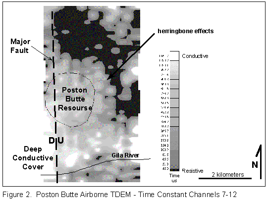
Program History and Methodology Victoria Island, NWT 1992 Studies initiated in 1991 indicated that available airborne TDEM technology could potentially identify weakly conductive (~100 ohm-m) targets in a moderately resistive host (500-1000 ohm-m) depending on target dimension and thickness. Discussions with the contractor also identified that on-time in-the-pulse and very early off-time measurements, although traditionally difficult to measure, did contain high frequency information outside the bandwidth of the system and hence could provide useful geologic information. Based on this concept Noranda commissioned the first commercial program where the very early time channels were compiled, revealing significant geologic information on the distribution of conductive and weakly conductive stratigraphy. Not only was the program innovative in its application, negative EM anomalies were identified which interpreted to be electromagnetic IP effects, provided additional targeting information (Smith, Klein 1996). The new information provided by this program helped geologists further their understanding of the target stratigraphy and became the impetus to broaden the application of airborne TDEM technologies. Poston Butte and Zeits, Arizona 1993 In 1993 Noranda undertook its first airborne TDEM test with the primary objective of subsurface mapping in areas of shallow cover (<150m) so as to help optimize the search for covered porphyry copper deposits. Two areas in Arizona were flown; Poston Butte (BHP’s Florence deposit) and Zeits (a Noranda Project). The objective of the surveys were to see if airborne TDEM could map resistive bedrock to a depth of 150-200m (the approximate open pit pre-strip economic depth limit). An additional potential benefit was the possibility of directly mapping the more conductive argillic and leached zones associated with a porphyry system. This direct targeting approach was recognized as being difficult given the problem of differentiating conductive responses associated with paleo clay zones or saline waters within the quaternary alluvial cover from conductive bedrock sources. The test survey over the Poston Butte
deposit, which is covered by up to 125m of post mineral alluvium, mapped
a crudely defined circular pattern within the later time channel calculated
time constant (tau 7-12) image that was coincident with the deposit location
(Figure 2). Noise levels and herringbone effects evident on the processed
images added to the ambiguity. While there is an element of speculation
(because of the lack of detailed ground information), the data supported
the interpretation that survey was mapping a conductive leach zone associated
with the porphyry. The known major structures (Nason et al., 1982) and
areas of thicker conductive cover were also clearly visible in the data
set.
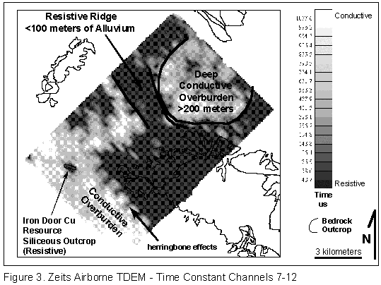
The Zeits survey also defined a circular
conductive feature within cover (Figure 3) which was close to a target
area previously defined by geologic mapping. (Herringbone effects are again
evident in the data.) The apparent analogy with Poston Butte was the impetus
for a rapid evaluation of the feature. A drill program was initiated on
the airborne TDEM conductors before ground validation (IP, TEM, gravity)
was completed to determine whether the anomaly sourced a surficial feature
or conductivity associated with a mineralized porphyry system. The drilling
failed to intersect basement but instead encountered a conductive clay
zone within the cover. The results underscored the need for thorough ground
follow-up programs to validate airborne TDEM interpretation.
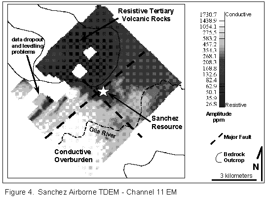
The correlation of mapped outcrop with resistivity highs (especially the Iron Door resource which is surrounded by cover), and broad low conductivity (resistive) zones located in areas of cover were initially ignored even though one of the program objectives was to map cover thickness. While the conductive EM anomalies were drilled and condemned, the subsurface geology of this covered exploration play was not appreciably advanced. It was not until later when the data was reevaluated and integrated with the complete geologic model, that the larger benefit of the airborne TDEM was fully appreciated. Assuming a uniform conductivity associated with the surficial layer, the areas of large conductivity (limited penetration?)more than likely map thick cover. Conversely, resistive areas (low amplitude, short time constant) more than likely map area of shallow cover. Integrating ground validation results and other geotechnical data with the airborne data, it was possible to derive a qualitative pseudo cover thickness image. Having a more robust model allowed for interpretation of alternative (e.g. low sulphide, oxidized Cu porphyry systems) or indirect target signatures (veins, silicified zones, etc.). Sanchez and Jordan 1995 Despite concerns arising from the perceived negative results of the Zeits program, application of airborne TDEM continued with surveys flown in 1995 over two areas in Arizona. The Sanchez resource, was flown along with a Noranda exploration project; Jordan, Arizona. The orientation survey over the oxidized Sanchez porphyry copper deposit suffered from several data quality issues and no clear signature was identified. ( Significant terrain relief made it impossible for the aircraft to maintain adequate flight specifications. Portions of coverage where the aircraft ground clearance exceeded 200m was removed from the database.) The resource however, is roughly mapped as a low conductivity zone (resistor) that appears to be controlled by northwest and northeast trending faults (Figure 4). Resistive areas to the north map Tertiary volcanic cover while conductors to the south and west correlate with known areas of deep overburden. A poorly defined, southeast trending moderate resistor, partially masked by conductive clays along the Gila river, is evidence of thin cover or conversely that a bedrock high trends southeast from the deposit (this is further supported by regional USGS gravity data). Recognition of this bedrock high later proved useful in developing an exploration strategy on the San Jose property.
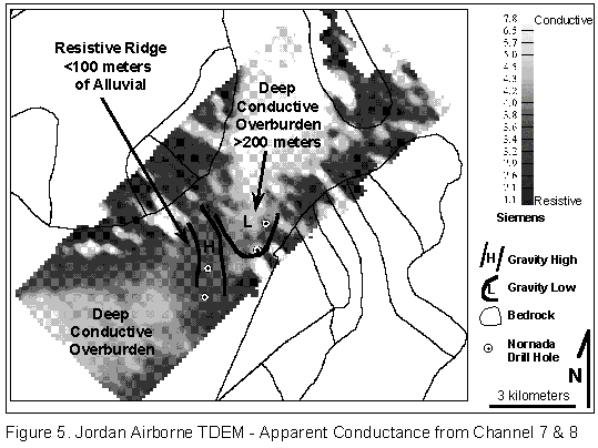
The Jordan survey defined a resistive
ridge trending through the middle of an alluvium covered valley (Figure
5). Gravity, magnetics, TEM soundings and follow-up drilling confirmed
that the resistive zone was indeed a basement high. The drill hole farthest
from the range front, approximately 2 km from the nearest basement exposure,
intersected the shallowest cover (103m) while holes near the range front
drilled over 200m of cover. TEM soundings on this project provided accurate
estimations to the cover thickness while gravity surveying reliably mapped
regional trends that corresponded with the airborne TDEM. Conductivity
lows (resistivity highs) correlated with gravity highs and mapped shallow
cover very well. Overall the results confirmed that airborne TDEM might
prove to be a useful regional basement mapping tool in covered terrain.
The amount of gravity surveying and TEM soundings required in covered exploration
programs was diminished with the use of airborne TDEM. Airborne TDEM does
not eliminate the requirement for follow-up ground programs but with baseline
programs and judicious selection of validation sites, overall saving in
time and expenditures can be achieved.
Zeits 1996 Based on our improved understanding
of airborne TEM applications from our results at Jordan, the Zeits airborne
TDEM data was re-evaluated and a more comprehensive geologic model was
developed with a broader consideration to alternative and indirect targets.
In particular a generalized cover thickness model was used as a guide to
help optimize exploration resources. The property was drilled again in
1996. While drilling in 1994 intersected over 200m of conductive cover
in the targeted annular conductor, the 1996 holes targeted in areas of
late time airborne resistors intersected less than 100m of cover in the
middle of a large covered valley approximately 5 km from the nearest basement
exposures (Figure 3). Although the later program had improved geotechnical
successes, no economic results were obtained. While the Zeits airborne
survey had shown that direct drill targets as such had not been identified,
it was shown to have significantly advanced the geologic model such that
a broader range of geologic targets could adequately and cost effectively
be drill tested.
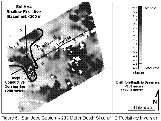
San Jose and Sol 1997 Previous surveys were affected by system configuration (base frequency, pulse width, magnetic moment, etc.) which were not optimized for surveying in conductive environments. Improvements in system noise levels and multi-component receiver measurements further advanced our mapping ability. The most significant advances which occurred between 1991 and 1995 were in the improved system performance. Better data was being provided by the contractors but processing techniques were still largely constrained by qualitative imaging techniques. The most significant advances were coming with the development of inversion algorithms which showed promise in unraveling complex responses and provide insight to the 3-D earth. Upon reflection of the work undertaken in the previous four years, Noranda was confident of the benefits of using airborne TDEM as a mapping tool. The San Jose and Sol porphyries presented the most difficult of area’s as a test case. Much of the pre-mineral basement depths were assumed to be over 200m and the nearest pre-mineral basement exposure is 5+ km away. The area is also covered by multiple alluvium and volcanic rock units (Houser et al., 1985) where past surveys were in alluvium covered areas only. The 1997 survey flown over Noranda’s San Jose property was expected to define lower conductive features associated with the pre-mineral bedrock. The overlying cover would be characterized by ostensibly horizontal conductive units where deep, penetration would not be obtained. The pre-mineral bedrock would display a more irregular profile reflecting major structures and paleo topography. The overall weakness in this approach is that a highly conductive porphyry leach cap or alteration zone might be mistaken as conductive cover. Thus, as in any interpretation, data integration is extremely important and anomaly follow-up a necessity. In this environment interpretation of airborne TDEM would need to follow an iterative cycle of geotechnical database interpretation and validation to avoid targeting of misleading surficial anomalies or ignoring legitimate bedrock features. Drill hole control at Sol (Yarter,
1981) shows the airborne TDEM conductivity depth transformation data to
have mapped known shallow (< 200 meters) basement areas (Figure 6).
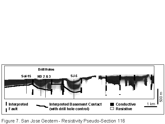
Beyond expectation and some would say beyond capability, empirical results
suggest that in resistive volcanic cover, basement can be mapped to depths
of 400 meters (Figure 7, drill hole SJ-5). The survey also mapped structures
and defined several characteristically distinct resistivity signatures
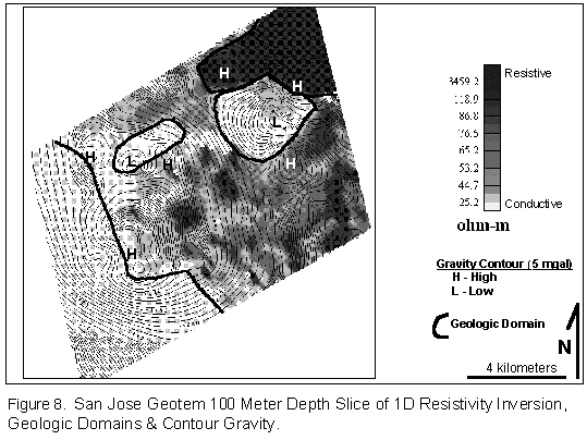
that likely represent different geologic (lithologic) domains (Figure 8).
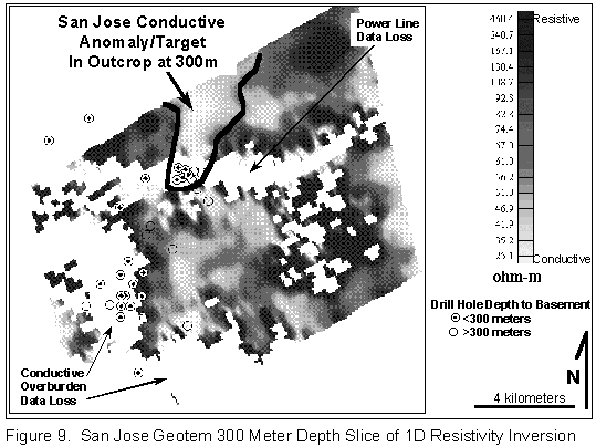
Noranda drilling at San Jose intersected
altered and mineralized basement at 200 to 300 meter depths. The conductive
features in the 300 meter depth slice (extracted from the topographically
corrected CDT sections) from this area may represent alteration and/or
mineralization associated with a porphyry copper system (Figure 9). In
this case, as at Poston Butte, the airborne TDEM could be mapping geologic
features associated with a mineralized porphyry system, and suggests that
at least locally, where we have validated the airborne data with drilling
(depth to basement), this data may be circumspectly used as a direct targeting
tool. Further ground validation of the resistivity data will ultimately
determine the various geologic features that the survey is mapping at San
Jose.
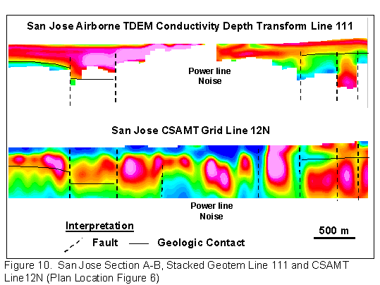
San Jose was Noranda’s most difficult, but also highly prospective property in Arizona and as such, many test geophysical data sets were acquired. These included TEM soundings, I.P., gravity, magnetics, CSAMT, and airborne TDEM. This facilitated data integration and comparisons between the airborne TDEM data and many of the ground geophysical methods that we had been using since 1993 in the covered terrain’s of Arizona. In previous projects generally only two detailed geophysical data sets were collected; Zeits - Airborne TDEM, I.P., Jordan - gravity, TEM sounding, airborne TDEM. The resolution of the airborne TDEM data is not that of CSAMT, however broad geologic features are often comparable (Figure 10). The cost effectiveness of airborne TDEM allows for more regional coverage which has proved to be a significant benefit. Results to date indicate that resistivity highs correspond well with gravity highs (Figure 8), thus facilitating more effective deployment of detailed gravity programs.
Induced Polarization/Resistivity programs
are expensive and often suffer from depth penetration problems in areas
of highly conductive overburden. Airborne TDEM faces similar constraints
but the lower cost and more detailed coverage (250-300m spaced airborne
lines versus 500-1000m spaced IP lines) facilitates improved overall mapping.
Experience with conventional IP programs in these areas has provided mixed
results when used solely for target definition. When used as selective
follow-up to an airborne program, IP can be more cost effectively deployed.
Conclusions A shift in our traditional focus of employing airborne EM as a direct targeting tool to that of a regional mapping tool has proven to be a significant advancement in Noranda’s use of this technology. While relatively simple in theory this transformation required new imaging and inversion technology (conductivity depth transformations), robust geologic models and ground validation (other ground geophysics, geochemistry, geology, drilling) followed by interactive phases of interpretation with each new phase of exploration. A shift in our approach to viewing EM data from "anomaly picking" to geologic mapping facilitates full use of the data and overall better target selection. Comparisons of the airborne data with the other geophysical data sets confirmed airborne TDEM as an efficient, rapid, and low cost method of reliable mapping and target identification in covered terrain. The airborne survey provides resistivity and magnetic data which combined provide an effective mapping tool. The airborne TDEM system is capable of >300 meters depth penetration in resistive and moderately conductive stratigraphy (>100 ohm-m) and present processing provides conductivity depth transform sections (pseudo conductivity sections) and depth slice plans that can help map geology in covered terrain’s, in particular depth to basement and regional structures. The resolution of airborne TDEM resistivity data can be comparable to but generally not as good as CSAMT. In conductive environments both tend to provide inadequate information but CSAMT will provide better results. However, for large porphyry copper exploration targets and regional mapping programs, airborne TDEM has proved to be a very useful and cost effective tool. In covered terrain, conductivity lows correspond well with areas of shallow cover, effectively mapping basement highs. and thus facilitating more focused and effective use of gravity surveys. Within this context the direct targeting potential can not be ignored but as with other geophysical methods requires a strong geologic perspective from which to properly evaluate anomalies. Ground validation programs are always required. Airborne TDEM has proven to be a useful
tool for mapping and in some instances has mapped geologic features associated
with covered mineralized systems. While airborne TDEM lacks the detail
of more costly ground surveys, recent advancement in this technology, mainly
in depth of penetration (improved signal/noise, multi-component, multi-channel,
greater magnetic moment, increased pulse duration, lower frequency/longer
off-time) and processing algorithms, has proved this a valuable regional
mapping tool.
References Annan, A. P., Smith, R.S., Lemieux, J., O’Connell, M.D., and Pedersen, R.N., 1994, Resistive-limit time-domain AEM apparent conductivity: Geophysics, 61, 93-99. Cooper, J.R., 1960, Reconnaissance Map of the Willcox, Fisher Hills, Cochise, and Dos Cabezas Quadrangles, Cochise and Graham Counties, Arizona: U.S. Geological Survey, Map MF-231. Houser, B.B., Richter D.H., Shafiqullah M., 1985, Geologic Map of the Safford Quadrangle, Graham County, Arizona: U.S. Geological Survey, Map I-1617. National Geophysical Data Center, USGS Gravity CD-ROM, 1994 edition: United States Department of Commerce MacNae, J.C., Smith, R.S., Polzer, B.D., Lamontagne, Y., and Klinkert, P.S., 1991, Conductivity depth imaging of airborne electromagnetic systems: Geophysics, v 49, pp 265-273 Nason, P.W., Shaw, A.V., Aveson, K.D., 1982, Geology of the Poston Butte Porphyry Copper Deposit: in Titley, S.R., ed., Advances in Geology of the Porphyry Copper Deposits: The University of Arizona Press. Sengpiel,K.P., 1988, Approximate inversion of airborne electromagetic prospecting data: Geophysics, V 48, no. 2, p.181-196 Sengpiel, K.P., 1986, Groundwater prospecting by multifrequency airborne electromagnetic techniques: ed G.J. Palacky, Airborne Resistivity Mapping, Geologic Survey of Canada, paper 86-22 Smith, R.S., Annan, A.P., Smith, R.S., Lemieux, J. and Pedersen, R. N., 1996, Application of a modified GEOTEM system to reconnaissance exploration for Kimberlites in the Point Lake area, NWT, Canada: Geophysics, 61, 82-92 Smith, R.S., Flat-lying conductor responses: A guide to interpreting asymmetric GEOTEM responses (herringbone) associated with overburden edges., Geoterrex publication, 1994 Smith, R. S., Klein, J., 1996, A special circumstance of airborne induced-polarization measurments, Geophysics, Vol 61, no. 1, pp 66-73 Yarter, W.V., 1981, Geology, Geochemistry, Alteration, and Mass Transfer in the Sol Prospect, A Sub-Economic Porphyry Copper-Molybdenum Deposit, Safford District, Graham county, Arizona: Masters Thesis, The University of Arizona, 136p. Wolfgram P. and Karlik, G., 1995, Conductivity-depth transformation of GEOTEM data: Expl. Geophysics, 26, p179-185 |
![]()
Web Template by
Round the Bend Wizards
GeoInfoSol.com © 2006